
Photo Record
Images
Metadata
Catalog Number |
DIGITAL01139 |
Subjects |
Panoramic photographs Ranches Homesteading |
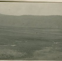
Description |
Part 1 of a panorama with DIGITAL01140. Walter May homestead on Tarheel Flat, southwest of Okanogan. Numbers on photo coincide with information on back which is "June 11: 1. camp, 2. road, 3. Mears land, 4. location of common in taking the other picture, 5. flume across flat (for irrigation water), 6. Colville Indians Res. 3 miles away, 7. W. C. lumber pile, 8. corners of our land except at road, 9. Mr. Can's corn field, 10. pot hole, 11. Ray place on bench of hill overlooking lower valley and river was first ?, 12. ranch showing ditches running around the hill on a water grade." |
Photographer |
Matsura, Frank S. |
Object Name |
Print, Photographic |
Date |
1911 |
People |
May, Walter |
Place |
Okanogan-Okanogan County-Washington (state) |
Search Terms |
Tarheel Flat Pleasant Valley Irrigation and Power Company |
Relation |
Show Related Records... |
Copyright |
If using this photograph, please give credit to: Okanogan County Historical Society. Please notify us of your use so that we may add it to our catalog. |
Notes on Related Objects |
Postcard photos included in Mary Jane May autobiography (daughter of Walter May) |